|
Costa Rica’s southwestern shoreline extending from Dominical south to the Panama border is called the Southern Pacific and Osa Peninsula region. Rain soaked, humid and one of the most picturesque the Southern Pacific and Osa Peninsula region is sparsely uninhabited and some of the most remote sections of all of Costa Rica. From the steep mountains of the Fila Costena mountain range rising from the Pacific below, to the largest stretch of primitive rain forest found anywhere throughout Central America. The Southern Pacific region, with over 200 inches of rain a year, is known as one of the most biologically different and stunning locations in the world. 
Unlike other parts of Costa Rica, the Southern Pacific region has a rainy season lasting from April till December, yet the area still receives rain through out the months of January to March.
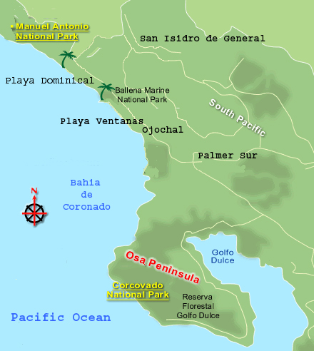
Traveling south along the Pan American highway from Dominical is Ballena Marine National Park, named after the Humpback Wales that migrate to the area during the months of December till April. Farther south is the Bahia de Coronado with the beaches of Utiva, Playa Ventanas and Playa Tortuga also referred to by the locals as Ojochal. Miles and miles of long white sand beaches give way to the occasional coves with rock strewn beaches and lush tropical forest cascading into the Pacific waters. Swinging farther west, the Bahia de Coronado follows the shore line of the Valle de Diquisa, a large flat plain bisected by rivers and estuaries. To the north of the Valle de Diquisa are the towns of Palmer Norte and Palmer Sur, and to the south the large Peninsula de Osa. Corcovado National Park with its large rainforest and its abundance of wildlife makes this area popular with the ecological minded tourist. The Oso Peninsula wraps around back to the north forming the Golfo Dulce. Continuing farther south along the Pan American highway the land gives way to the Valle de Coto Colorado. Large banana plantations extend through the two valleys from Palmer Norte south to Golfito. Farther south the region gives way to more tropical rain forest and the remote Peninsula Burica that Costa Rica shares with Panama.
The Southern Pacific region also is home to the isolated and volcanic Coco Islands and the Coco Island national Park, located some 300 miles southwest of the Osa Peninsula, the islands are a must see destination for scuba divers. Large and diversified marine species and schools of sharks, dolphins and sea rays make this a diver’s paradise.
|